Yosemite’s Half Dome might be the most iconic hike in the United States. This soaring granite batholith, which is second only to El Capitan on Yosemite’s impressive skyline, looks as if a divine scimitar has cleaved it in half; its southeast side slopes up to a summit like any other dome, but its northwest face is a sheer vertical wall that plunges back to the valley floor. Half Dome rouses the imagination and practically begs to be climbed. George G. Anderson first ascended it in 1875, barefoot and without modern climbing equipment, by drilling holes in the granite and placing iron spikes. Over the decades, those holes evolved into a set of cables that park rangers raise every spring to help day hikers clamber up the final 400 feet to the summit.
Ascending the Half Dome cables to the summit is an intimidating lifetime achievement for many hikers, but it takes tremendous effort just to get there. AllTrails clocks the roundtrip trail at 16.5 miles, with 5,305 feet of elevation gain. Even without the cables, this would be the hardest hike I’ve ever done, excepting a 23-mile up-and-down of Pike’s Peak when I was 25 years younger.
This is the one must-do hike during Sam’s visit.
—
Unfortunately, Half Dome’s reputation entices more hikers than can safely ascend and descend the precarious cables. In 2010, Yosemite began requiring permits, which are assigned via lottery. The park issues only 300 permits per day. I’ve read that during peak seasons the probability of winning the lottery is around 15%.
We only have two full days in the park, Saturday and Sunday, the hardest days to win the lottery. Nonetheless, we try. Hannah, Sam and I each dutifully pay $10 to enter Saturday’s lottery. When none of us win, we try again for Sunday. No luck.
The summit is out, then. That’s unfortunate, but it doesn’t deter us. We’ll do as much of this hike as we can. I hiked the first three miles of this trail several years ago, with my family. The twin waterfalls, Vernal and Nevada Falls, make this a world-class hike even without Half Dome.
—
We get a later start than I hoped, but since we’re not summiting, I don’t feel rushed. When we arrive on the valley floor, we encounter our first setback: all the roads near the trailhead are closed for construction. We drive to Yosemite Village, two miles away. Our plan is to catch the purple shuttle back to Curry Village, but when we arrive at the bus stop with our daypacks and trekking poles, we learn that the purple line is shut down. Our options are to take the green shuttle the long way around, requiring 50 minutes, or walk. I’m a little shocked at what feels like disastrous logistics planning in support of the construction; somehow, I expected park management to be as pristine as the wilderness.
We opt to walk, which means our 16.5 mile hike has just become 20.
—
The trailhead is located on the far side of a footbridge that crosses the Merced River, which we’ll be following upwards for most of the day. The trail is initially paved to facilitate the throngs of hikers, but it also climbs steeply, as if resolved to shake as many of them loose as quickly as possible. Many turn around at the first scenic overlook, beneath Vernal Falls. After that the crowds begin to thin, and the trail turns to dirt.
The diversity of tourists here makes a striking and happy contrast to Truckee. Nobody likes crowds of tourists, but I’m legitimately happy to see people of all shapes, sizes, and skin color enjoying Yosemite. We hear a dozen languages. Elderly people and small children share the path with intrepid hikers outfitted with cutting-edge gear. I’m not sure why they flock here and not places like Truckee; Yosemite isn’t any less expensive. Possibly it’s just awareness; Yosemite is legendary, while most people have probably never heard of places Truckee or Yosemite’s lesser-known but equally gorgeous sibling, King’s Canyon.

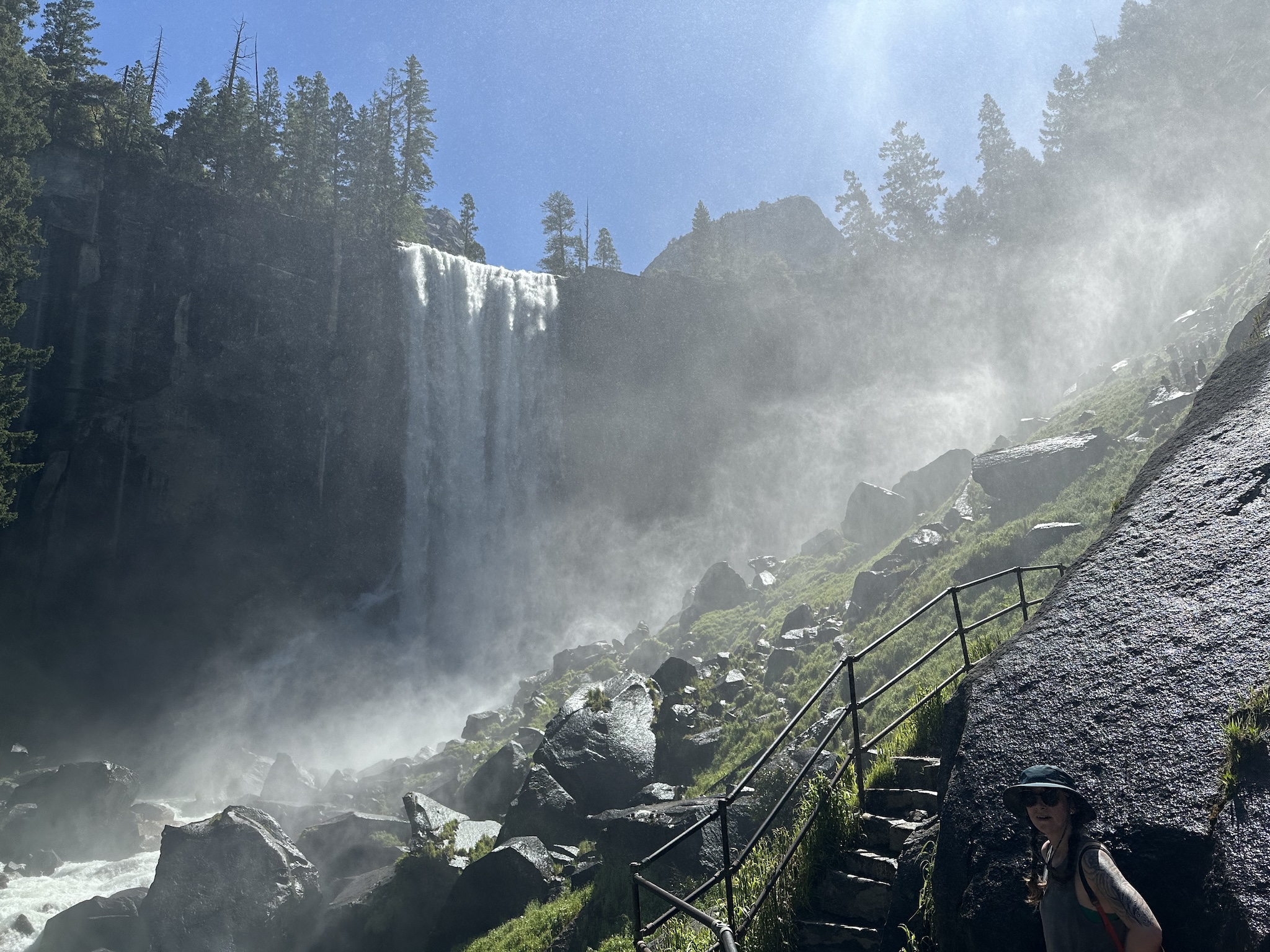
I’m impressed by how many people continue the hike past the overlook. We soon reach the trail’s most spectacular stretch, steep stone stairs winding past Vernal Falls. My daughter remembers these stairs with fear. They feel more dangerous than they are, a fleeting brush with mortality, which left a lasting impression. A refreshing spray hangs in the air, cooling our bodies and wetting the stone. Bright rainbows twist and play at every angle.
At the top of the falls, hikers warm themselves and eat snacks on the bright granite. The squirrels are hopelessly domesticated, fat and fearless. We know better than to feed the wildlife, but Hannah feeds them anyways; they’re already ruined.
—
From Vernal Falls, it isn’t much more of a hike to Nevada Falls. We make another steep climb, this time out of the spray, to a spectacular overlook. A footbridge crosses the Merced, right where it hurls itself down the steep cliffside with unimaginable force. I look for a sign I remember, which warned tourists, “If you go over the falls, you will die.” I don’t see it. Maybe the park service’s refreshing candor has fallen out of fashion. That’s a pity; I’ve read that the leading cause of death in Yosemite is tourists falling in the river from this trail. That doesn’t surprise me, given the number of people I’ve seen jumping over guardrails for selfies.
The upper reaches of the falls is where my family and I turned around before. It feels like a natural ending place, flat, expansive, with a feeling of summiting.
It’s hard to believe we’re only halfway, measured by both distance and elevation. We’re tired. I’m concerned about Hannah, who has never done anything this strenuous. She’s been strong and consistent thus far, but sooner or later, she’ll hit a wall. And Sam, for all his hiking prowess, has little experience with hikes this long or at such high elevation. His hydration consists mostly of Mountain Dew, his lifelong vice of choice, with occasional gulps of water at my insistence.
We take our time eating lunch. We take naps. I still feel unrushed. We have all day.
—
The next stretch of trail is hard. It gets harder, and then it gets miserable.
The majestic views of Yosemite Valley, and the refreshing waterfalls, are gone. We hike a long flat stretch of forest trail, coming around Half Dome from the back side. Then the ascent starts. We have 2,000 feet to gain this way, trudging up meandering forest switchbacks. Everything hurts. Our prolonged rest gave our muscles time to seize up.
Our breaks become more and more frequent. I ignore mileage but check my watch altimeter every minute or two. We need to gain 2000 feet but are only ascending 50 to 75 feet between breaks. Time flows by. At first I insist we can take our time, saying we can rest as often as needed. But as the afternoon rolls past, I start to watch the clock. I’m meticulous about safety, but of all things, I forgot to pack the headlamps. Sunset will bring a precipitous drop of temperatures and then absolute darkness. We discuss options and turnaround criteria.
Hannah gradually approaches her limit. Eventually, an hour before our hard turnaround time, she makes the decision to wait on the trailside while Sam and I finish the hike. Sam and I forge ahead. I’m still checking my altimeter. We can’t climb the Half Dome cables without a permit, but we plan to climb the subdome. Not long after we part ways from Hannah, we break into the open and see Half Dome and the subdome looming above us. I’m still wary of time. The subdome looks brutal in its own right, with 400 feet of elevation gain on steep switchbacks.

And then, suddenly, we’re at an end. At the base of the subdome, a sign warns that permits are required to go further. That’s it. We’re done, 400 feet lower than expected. There isn’t anything to do; I’m not interested in defying the rules. Yosemite’s rangers have seen it all, and I don’t expect they’ll have any qualms about hitting us with the advertised $280 fine.
It’s disappointing to be this close, watching those little toy figures above us inching their way up the cables to the summit. But we’ve done what we can. Maybe someday we’ll return.
—
Over the years, I’ve learned that I never need to save much for the descent. Descending takes care of itself. Gravity does most of the work. I only need a little water, and no food. The main challenges are knee pain and blisters. Still, I’m not sure if the same will hold true for Sam and Hannah.
The descent is mostly monotonous trudging. I’m amazed how long the trail goes, how much ground we covered on the way up. I didn’t realize.
We stop for water at Little Yosemite campground, near the top of the waterfalls. The moment Sam stops, he gets severe cramps and feels nauseated. Dehydration is almost certainly a factor. We force him to drink water, and this time he acknowledges that would be a good idea.
Then we continue on. Somewhere along the way, the sun disappears behind Yosemite’s tall granite walls. It gets cooler. Hours pass, and still the trail goes on.
When we reach the valley floor—the supposed end of our hike—we still have to find our way those two miles back to our car. We walk a mile to Curry Village, then mercifully catch a green line shuttle direct to Yosemite Village.
—
Outdoor enthusiasts talk about Type 1 vs Type 2 fun. Type 1 fun is “enjoyable while it’s happening.” Type 2 fun “is miserable while it’s happening, but fun in retrospect.” (There is also Type 3 fun, which isn’t actually fun at all, even in retrospect)
This was good old-fashioned Type 2 fun. For someone without much experience hiking, Hannah’s performance was incredible. Sam is happy. By the end of the hike, I never want to hike again. In a few days, I’ll be eager to go again.
